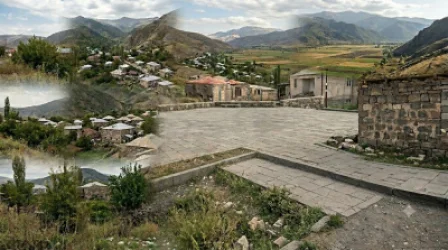
Animal Farm of Shurnukh Resident Divided into Two Parts: 'Azerbaijani' and 'Armenian', Ombudsman

The animal farm belonging to Shurnukh resident Styopa Movsisyan, located directly next to his house, has been divided into two sections – 'Azerbaijani' and 'Armenian' – as a result of the application of GPS (Global Positioning System) or Google Maps. This information has been reported by the Office of the Human Rights Defender (Ombudsman).
Moreover, both the house and the animal farm have valid property rights confirmed by certificates from the State Committee of the Republic of Armenia for Real Estate Cadastre.
In fact, we tested several versions of Google Maps in the vicinity of the house, each showing different results, including representations where Styopa Movsisyan's house and the entire village of Shurnukh were depicted as part of the territory of the Republic of Armenia.
Unfortunately, such stories are numerous today. Specific examples like this demonstrate that the current approaches to border determination, particularly the mechanical application of GPS or Google Maps, have endangered, and especially violated the rights of residents along the border of Armenia regarding property and other rights. People are unable to utilize their property even with ownership certificates.
Thus, such mechanical approaches in determining the state borders of the Republic of Armenia and the rapid processes involved must be completely excluded. Professional approaches, the results of scientific research, detailed on-site commission work, and appropriate legal foundations are urgently needed.
Նմանատիպ հոդվածներ
The Directors of the National Security Services of Armenia and Azerbaijan Discussed Issues Regarding Prisoners and Missing Persons
Nikol Pashinyan to Visit Russia for Meetings with Vladimir Putin and Ilham Aliyev
URGENT: The trilateral meeting of Pashinyan, Putin, and Aliyev has begun in Moscow
Official Statement to Follow Results of Trilateral Meeting, Says Armenian PM's Spokesperson
Ավելին Politics բաժնից

Ինչո՞ւ է Ավետիք Չալաբյանը կրկին հայտնվել իշխանությունների թիրախում. Փաստ

Չօգնեց նույնիսկ ԵՄ-ի և ԱՄՆ-ի անթաքույց աջակցությունը. ընտրությունները՝ նաև յուրատեսակ հանրաքվե. Փաստ
Նոր ընտրություններ են սպասվում. կմիավորվեն ևս 4 համայնք և 54 բնակավայր. «Փաստ».