Border Demarcation Completed, Agreed Upon, and Signed in the Specified Areas: Prime Minister's Office
The Information and Public Relations Department of the Prime Minister's Office has responded to the questions from Armenpress regarding the statement issued on May 15 by the Armenian and Azerbaijani border delimitation commissions.
The Q&A is presented below:
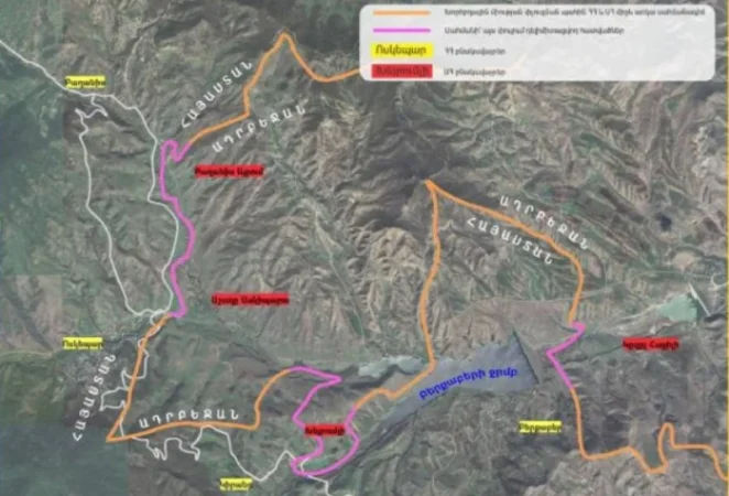
Question: The Armenian and Azerbaijani delimitation commissions have released a joint statement indicating that the border descriptions and protocols have been agreed upon based on the topographic maps with legal foundations from 1976 created by the USSR Armed Forces General Staff in the sections of Baghanis in Armenia, Baghanis-Airum in Azerbaijan, Voskepar in Armenia, Ashagy Askipara in Azerbaijan, Kiran in Armenia, Kheiremli in Azerbaijan, Berkaberd in Armenia, and Kyzyl Haji in Azerbaijan. What does this mean?
Answer: As you are already aware, border pillars have been installed by the relevant working groups in the specified areas to designate the previously agreed-upon coordinates. These coordinates were taken from the aforementioned 1976 maps. Now, the cartographers have agreed on the boundary lines between the pillars, again based on the same maps. In other words, the reproduction of the border line in these areas has been completed, agreed upon, signed, and the boundary in these sections is considered delimited.
Question: Why were the 1976 maps chosen, which, as noted in the delimitation commissions' press release, were used by the USSR Armed Forces General Staff?
Answer: This is, in fact, the de jure legal basis map at the moment of the collapse of the Soviet Union. It was fundamental for the Armenian government to approach this matter from the perspective that a new border is not being created between Armenia and Azerbaijan, but rather, the de jure existing border at the time of the Soviet Union’s collapse is being reproduced.
Question: The commissions’ statement mentions that these maps underwent a procedure of duty in 1979. What does this mean, and why were 1990 maps not considered?
Answer: That formulation is legal terminology, meaning that the competent authority in the field of cartography and geodesy in the USSR verified the accuracy and legal foundations of the map in 1979. These maps were used up until the collapse of the Soviet Union. In other words, they are the most recent maps verified by the competent state bodies of the USSR.
Նմանատիպ հոդվածներ


Ավելին Politics բաժնից

Անդրանիկ Թևանյանի կալանքը երկարաձգվեց 2 ամսով

Վախկոտ փոքրիկ խմբակի սրտի ԿԸՀ-ն գնաց հերթական ապօրինության. Ղահրամանյան

ԿԸՀ-ն համաձայնություն է տվել Նարեկ Կարապետյանին մեղադրանք առաջադրելու հարցին. Վարդևանյան