Lydian Presented Unreliable Facts to the Government: Ecoline Files Criminal Report
The Armenian Environmental Front has filed a criminal report with the Prosecutor's Office. They made this known in a statement, which we present below.
“To the Prosecutor General of the Republic of Armenia,
We request that this case not be forwarded to other law enforcement agencies. The final report of the studies ordered within the framework of the criminal case initiated by the Investigative Committee of Armenia regarding the Amulsar issue indicates, with detailed arguments available on the official website of the Investigative Committee, that the completeness, reliability, and scientific justification of the reports presented by Lydian Armenia (formerly Geoteam) to the Armenian government in 2016 have not been ensured.
Lydian Armenia has failed to fulfill its obligation to ensure the completeness, reliability, and justification of the materials presented. These are gross violations of the legislation of the Republic of Armenia, based on which the company should be examined and held liable under the law's strictness. Since the announcements from the Investigative Committee hide these publicly disclosed violations, we request that this report be investigated and all arguments present in the mentioned document be subjected to examination.
Given that the overall material is extensive, we present two examples:
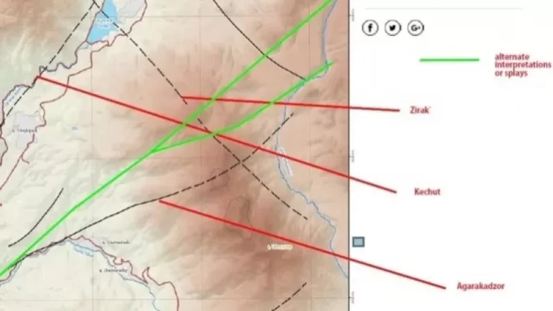
1. According to one of the points of the technical assignment from the Investigative Committee, one of the objectives of the studies by the Lebanese ‘ELARD’ and the American ‘TRC’ companies was the following: ‘To understand and evaluate the scientific accuracy of the claim made by Lydian that Amulsar is a separate/isolated geological block.’
In connection with this issue, it is noted on page 39 of the report: ‘The area of the project is only partially included within the tectonic block of Amulsar. The entire territory of Tigranes-Artavazdes-Arshak quarry and at least part of the Erato quarry are located within the Agarakkazor fault and the southern part of the ATB. Moreover, the DAL is situated on both sides of the Zirak fault, some parts of the DAL lie north of the fault and ATB. At least half of the Kechut Reservoir is within the ATB, near its northern peak. Percolation from the part of the DAL north of the Zirak fault could lead to contaminated water reaching the Madikents springs. Meanwhile, the groundwater beneath the quarries can flow into the Darb and Vorotan rivers. The location of the Darb and Arpa rivers has structural dependence; rivers are typically hydrological boundaries (there is no groundwater flow in the projection direction). Additionally, the faults can obstruct the flow of groundwater, and the hydrothermal alteration increases the likelihood that the faults obstruct groundwater flow. However, since most of the DAL and the quarry areas are located outside the tectonic block of Amulsar, it is incorrect to state that the mine cannot affect the regions (including freshwater resources located near the ATB). Furthermore, the faults can serve as conduits for groundwater flow. This probability indicates that the Agarakkazor fault could transport contaminated groundwater to the Darb and Arpa rivers, while the Zirak fault could carry contaminated groundwater, including the potentially leachate water from DAL (at an elevation of approximately 2600m), towards the Kechut reservoir (at an elevation of approximately 1950m) and/or the Vorotan river (at an elevation of approximately 2200m, at the designed intersection of the Zirak fault). Surface and groundwater moving northward from DAL flow in a northwest trajectory towards the Arpa river and the Kechut reservoir.’
Please note that Lydian has insisted for years that the tectonic block of Amulsar (ATB) is independent not only in geological structure but also in engineering-hydrogeological features. The hydrogeological regime of the block is also independent; it does not relate to the freshwater basins of nearby areas and cannot have any impact on their hydrogeological conditions and groundwater regimes and chemical compositions during mineral extraction. The morphology of the geological block of Amulsar provides the hydrogeological (autonomous) conditions. This is stated in Appendix 21 of the 2016 EIA. Similar statements are also found in the GRZ (2011) and Geoteam (2014) documents and on the website of ‘Lydian International’.
We also draw your attention to the fact that the report repeatedly mentions that ‘The Quarries and the Waste Rock Piles are in the immediate vicinity of the waters of Lake Sevan… Lake Sevan is protected under Armenian law, which prohibits any activity that could adversely affect the lake and its ecosystem.’ Meanwhile, the Kechut Water Reservoir is a water-supplying source for the Arpa-Sevan tunnel.
2. The final paragraph of Section 2.1.3.1 of the Waste Rock Piles (DAL) head states: ‘No assessment of the impacts on groundwater has been conducted, meaning that no mixed calculations have been performed. No simulation of the transportation pathway has been conducted in either the regional groundwater model or by any other means.’ Hence, it turns out that Lydian has previously submitted unreliable, incomplete, and scientifically unsubstantiated facts to the Armenian government, while the state authorized body issued a positive conclusion on the environmental expertise. If necessary, we are ready to present more facts.”
Նմանատիպ հոդվածներ

Ավելին Incidents բաժնից

ՏԵՍԱՆՅՈՒԹ․ Հրկիզված մեքենաներ, թալանված խանութներ․ Փարիզում զանգվածային անկարգություններ են

Երթևեկությունը կսահմանափակվի՝ Աջափնյակ վարչական շրջանում

Առատ տեղումներ՝ կարկուտ և քամու ուժգնացում է սպասվում